

TRUSTED BY CATCHMENTS, FARMERS AND PRIMARY SECTOR LEADERS


Scaling from pilot to hundreds of farms is hard.
The wrong tools make it harder.
Slow progress coordinating change with static data sets across GIS, spreadsheets, pdf reports.
No single source of truth - everyone works from different maps.
Reporting progress and impact is slow, fragmented and hard to prove.
CarbonCrop is the one platform for your whole restoration project lifecycle.
Unify planning, delivery, and reporting in a single, proven platform.
What makes CarbonCrop so powerful?

Clarity and speed from the start
-
Rapidly assess, map, and prioritise interventions
-
High-resolution automated mapping and integrated environmental data layers.
-
Make confident, evidence-based decisions on where and how to act.
Align with carbon incentives
-
Map existing native forest and plan new planting areas
-
Auto-generate ETS ready shapefiles and documentation
-
Prepare credible evidence for submission and audit

Coordinate across stakeholders
-
Everyone has the same live project view
-
Preserve project integrity with role-based access
-
Keep everyone aligned, reduce duplication, and adapt quickly to change.
Proof of impact, always ready
-
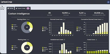
Track progress in real time.
-
Share progress instantly – no manual reporting scramble.

Whether you're working over 5 sites or 500, the CarbonCrop platform grows with you.
+5 million
Hectares of land assessed in NZ
+300
Farms projects supported
+$35 million
Carbon revenue delivered to landholders
